Rocky Mount “Eagle” Airport, as depicted on the 1935 Norfolk Airway Chart.
According to 11/22/30 Charlotte Observer article (courtesy of Mark Hess), Eagle Airport was established on 7/2/30 by the Eagle Aircraft Company.
The earliest airfield directory entry which has been located for Eagle Airport
was in The Airport Directory Company’s 1933 Airports Directory (courtesy of Chris Kennedy).
It described Eagle Airport as a commercial field located ½ mile north of Rocky Mount.
The airfield was said to consist of a 4-acre rectangular sand & sod field, measuring 1,400′ by 1,200′.
The 1934 Department of Commerce Airfield Directory (courtesy of Chris Kennedy)
listed Eagle Airport as a municipal airport, located “One mile north of Rocky Mount, just north of Tar River on west side of Highway #40.”
The airfield was described as consisting of a rectangular sand & clay field, measuring 3,600′ north/south by 1,400′ east west.
Hangars & buildings were said to be located along the southeast side.
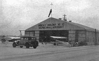
The airport was evidently renamed Rocky Mount Municipal Airport at some point between 1934-36,
as that is how it was labeled on a hangar pictured in the 1936 book “Emergency Relief in North Carolina” (courtesy of Nick Demilio).
An undated aerial view looking south at Rocky Mount Municipal Airport
from the Airport Directory Company’s 1937 Airports Directory (courtesy of Bob Rambo).
The field was described as having a 3,600′ x 1,500′ sand & sod landing area.
An undated aerial view looking northeast at Rocky Mount Municipal Airport
from the Airport Directory Company’s 1941 Airports Directory (courtesy of Chris Kennedy).
The field was described as having a 3,600′ x 1,800′ sand & sod landing area.
A single hangar was depicted on the east side of the field.
The directory contained an advertisement for the Rocky Mount Flying Service.
A 12/15/42 aerial view looking north at Rocky Mount Municipal Airport
from the 1945 AAF Airfield Directory (courtesy of Scott Murdock)
depicted a dramatic transformation of the airport compared to the 1941 directory photo,
with the previous grass landing area replaced by 2 asphalt runways.
The 1945 AAF Airfield Directory (courtesy of Scott Murdock) described Rocky Mount Municipal Airport
as a 286 acre irregularly-shaped property within which were 2 bituminous runways, measuring 4,000′ NNW/SSE & 3,800′ NNE/SSW.
The field was said to have a single 100′ x 80′ steel hangar,
to be owned by the City of Rocky Mount, and to be operated by the City of Rocky Mount & private interests.
The 1960 Jeppesen Airway Manual (courtesy of Chris Kennedy)
depicted Rocky Mount Municipal as having 2 paved runways (4,005′ Runway 15/33 & 3,785′ Runway 3/21),
as well as a taxiway leading to a ramp on the southeast side of the field with a single building (a hangar?).
Rocky Mount Municipal Airport was described in the 1962 AOPA Airport Directory as having 2 paved runways,
and the operator was listed as Rocky Mount Air Service.
The Aerodromes table on the 1965 Norfolk Sectional Chart (courtesy of John Voss)
described Rocky Mount Municipal as having 2 asphalt runways, with the longest being 4,005′.
In the words of Joe Benson,
“I flew a Cessna 210 from Opa Locka up to RMT in 1967 & I landed on Runway 21.
The next night, [I departed] off of Runway 3.
The only buildings even then were the FBO right on US 301.”
Jan Chamblee recalled, “Living in Nash County most of my life, my family made frequent trips to Rocky Mount in the 1960s through 1980s.
I remember cropdusters & private aircraft flying out of there.
I recall being on the airfield & seeing the cropdusters parked at hangars that backed up
to a convenience store / gas station property adjoining Centura Highway which was Hardees Boulevard at that time.”
The 1968 Flight Guide (courtesy of Bob Levittan) depicted Rocky Mount Municipal as having 2 paved runways: 4,000′ Runway 15/33 & 3,785′ Runway 3/21,
as well as a taxiway leading to a ramp on the southeast side of the field with a single building (a hangar?).
Rocky Mount Municipal Airport was renamed Rocky Mount Downtown Airport
at some point between 1968-72,
after the larger Rocky Mount Wilson Airport had been built to the south.
“Rocky Mount Downtown” Airport was depicted on the August 1972 Charlotte Sectional Chart (courtesy of Robert Brown)
as having 2 paved runways, with the longest being 4,000′.
A 1975 USGS aerial view depicted Rocky Mount Municipal Airport as having 2 paved runways,
with a ramp, several buildings & what appeared to be several light planes on the southeast side.
The last aeronautical chart depiction which has been located of Rocky Mount Municipal Airport
was on the November 1976 CG-21 World Aeronautical Chart (courtesy of Chris Kennedy).
It depicted “Rocky Mount Downtown” Airport as having 2 paved runways, with the longest being 4,000′.
The 1977 USGS topo map depicted the “Municipal Airport”
as having 2 paved runways, with a few small buildings on the southeast side of the field.
A 3/1/77 USGS aerial view depicted Rocky Mount Municipal Airport as having 2 paved runways,
with a ramp, several buildings & a row of light planes on the southeast side.
Ken Stallings recalled, “The old KRMT airport in Rocky Mount… That was the airport for my hometown as I was growing up.
The FBO at the airport from at least the early 1970s until the airport was closed was known as Air Care, Inc.

There was also a crop duster operation there named Air-Ag, Inc. which was affiliated with the Air Care operation.
These 2 operations moved to the new KRWI airport when it opened, but remained at the old municipal airport until it closed.
The hangar from a 1930s photo remained in use until the airport was closed & remained the largest single building at the airport.
However, a few smaller facilities were constructed.”
Ken continued, “All of the additional buildings were aligned along the eastern side of Runway 03/21 so that it would have access to Business 321 highway.
Interestingly, during this time, the headquarters of Hardees was located across 321 from the airport. My dad worked there as a restaurant manager.
The additional airport buildings were 2 single-story facilities that served as the FBO management building
and pilot briefing room & lounge for the Air Care & Air-Ag operations.
The Air Care FBO office was next to the large hangar in [the] 1930s photo, and was across a small parking lot off 321 about 75 yards southwest of that hangar.
Another single-story structure was located about 200 yards northeast of the large hangar
and served as the headquarters building for the Air-Ag operation.
The Piper Pawnee& Cessna aircraft were parked on the grass next to this one office.
General aviation parking was in an open apron located on the west side of the large hangar & extending SW to the FBO building.
From RMT is where I took my very first airplane ride on my 16th birthday back on 6/7/79.
It was in a Piper 4-seat model, likely Archer or Cherokee.”
The 1980 USGS topo map depicted the “Rocky Mount Downtown” Airport as having 2 paved runways
The last photos which have been located showing Rocky Mount Municipal Airport still in operation was a series of 1980 photos by Mike Massimini.
This picture shows a Piper Tri-Pacer; Mike observed, “Past the Tri-Pacer you can see the cinderblock structure added on to the original hangar.
There were offices as well. At the very left you can see the edge of the building Hardee’s used as its headquarters.”
Mike Massimini recalled, “I worked for Air Care, Inc. at the time this airport was closed.
This FBO had operations at both RMT & RWI, but all aircraft maintenance & administrative offices were at RMT.
I flew Aztecs, a Seminole, a Bonanza, and a couple of Arrows while I was there, as well as the usual CFI stuff.
I last flew out of RMT on 9/16/80. The transition had been in progress for about a month & was completed a few days later.
All operations at RMT ended, and the airport was officially closed.
The crosswind Runway 15/33 had already been closed long before I started working there in March of 1980;
departing [Runway] 15 would set you up for a buzz job of Hardee’s corporate headquarters which was across the street (Church Street / US 301) back then.
Nevertheless, we’d occasionally land on [Runway] 15 during periods of strong (favorable) winds.
The fence northwest of the airport had a car-sized gap & unimproved access to this runway.
Those of us living in this direction could take this short cut & drive down the closed runway to the FBO (looking both ways as we crossed [Runway] 3/21, of course).
Not advisable in this day & age.”
A 1980 photo by Mike Massimini of A Piper Aztec inside a Rocky Mount Municipal Airport hangar.
Mike observed, “N44AC was the main charter airplane, and is shown in a maintenance hangar.
The big hangar shown in the earlier pictures still existed, but had this smaller structure added on, as well as a Quonset hut type structure on the other side.
This Aztec had an enlarged cargo door – you can just make out it’s outline.
It disappeared one Friday night; [it was] eventually found gear-up in a Jamaican field with traces of marijuana in the cargo area.”
A 1980 photo by Mike Massimini at Rocky Mount Municipal Airport, from “in front of the FBO looking northwest towards the end of Runway 21.”
The 1983 USGS topo map depicted the “Muni Airport” as having 2 paved runways.
According to Jan Chamblee the Rocky Mount Downtown Airport was evidently closed “around 1983 or 1984
since I participated in sports car autocross on the closed runways during that time frame.
These events were sponsored by the Tar Heel Sports Car Club.”
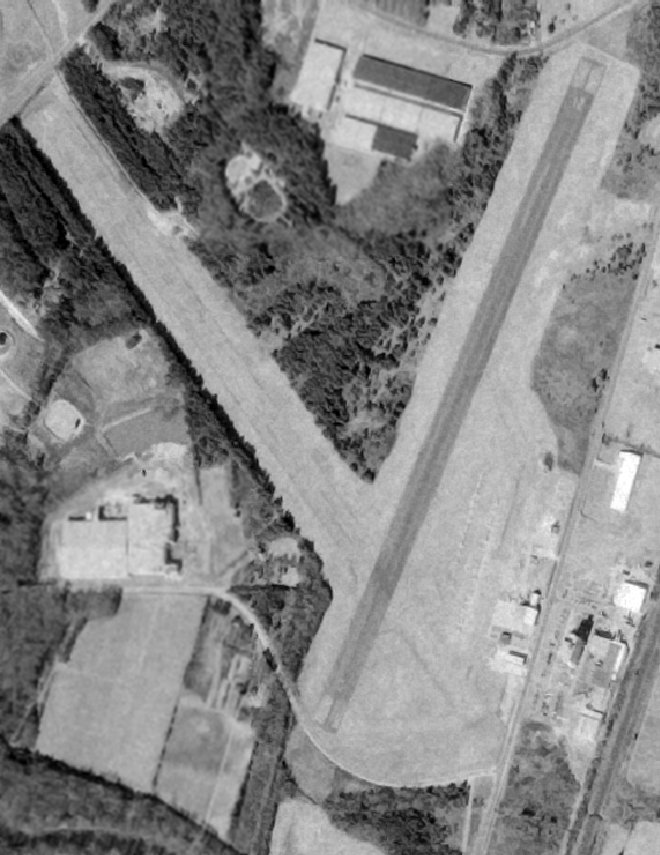
A 1993 USGS aerial photo showed both runways still remained largely intact, but marked with closed-runway “X” symbols.
A stadium had been built over the southern end of Runway 3.
Joe Benson continues, “The parking ramp was still there when I visited in 1994 but no buildings of any kind.
The stadium was there but you could drive the full length of both runways.
I was sitting on the centerline in my Bronco & a cop came by & just stared at me but didn’t stop.
A penny for his thoughts. I guess he couldn’t tell when someone is reminiscing.”
Adelia Ramey (of the City of Rocky Mount’s Department of Planning & Development) recalled in 2005,
“When we first moved here in 1997 the site was used for recreational soccer.
There were 1,000 kids & their families swarming all over the fields & using the runways as a parking lot.
That stopped about 6 years ago [1998] when they discovered the contamination.
It was from the crop dusters dumping out their tanks on the ground. It took a long, long time to clean up.”
A 1/25/98 USGS aerial view looking north showed both runways still remained largely intact,
and the Runway 33 markings were still visible.
A 2000 photo by Paul Freeman looking northwest along the abandoned Runway 33.
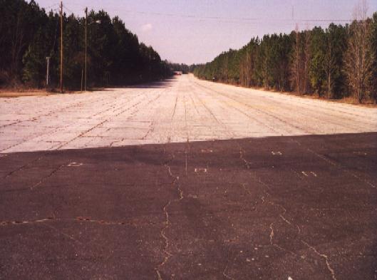
Both runways were still very much in existence, but trees had grown right up to the edge of the pavement.
A small football stadium had been built on the portion of Runway 3/21 below the runway intersection,
and Runway 15/33 was apparently used for parking for stadium events (and was open & accessible by car).
Most of the northern end Runway 3/21 was fenced off,
with a sign indicating that it will not be open for public access until cleanup of hazardous materials is complete (buried fuel storage tanks?).
No evidence of hangars or other former airport buildings were noticeable.
Rocky Mount Municipal was still depicted on 2002 sectional charts as an abandoned airfield.
Rocky Mount resident Nick Demilio reported in 2003, “The old runways are still there.
They have been used as storage pads for various materials by the city (recycling collection points),
for people to take their teenagers out to practice driving away from the traffic, and not much else.
The city built the ‘Rocky Mount Athletic Complex’ there over 20 years ago.
Rocky Mount Senior High plays its home football games there.
The city has been talking for years about turning the rest of the ‘old airport’ property
into a more ambitious municipal athletic complex with many baseball, softball, and soccer fields.
That plan is supposedly ready to start building after being held up by the hazardous waste found there…
not old aviation-related stuff but PCB’s contaminating the soil – how they got there I don’t really know.
It is an official ‘Superfund’ site and has been cleaned up.
The pavement is cracking but still drivable,
and some of the old markings painted on the runways are still there.”
The City of Rocky Mount’s website described the “Rocky Mount Sports Complex” as “opening Fall 2006”.
It said “Work on the Rocky Mount Sports Complex is moving forward at a rapid pace,
and the old airport grounds are moving aside for ‘fly balls’ instead of flying planes.”


